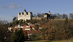
Town in Thuringia, Germany
| Ranis | |
|---|---|
| Town | |
 Ranis Castle Ranis Castle | |
 Coat of arms Coat of arms | |
Location of Ranis within Saale-Orla-Kreis district
 | |
  | |
| Coordinates: 50°39′50″N 11°34′5″E / 50.66389°N 11.56806°E / 50.66389; 11.56806 | |
| Country | Germany |
| State | Thuringia |
| District | Saale-Orla-Kreis |
| Municipal assoc. | Ranis-Ziegenrück |
| Subdivisions | 4 |
| Government | |
| • Mayor (2022–28) | Marcus Pavel |
| Area | |
| • Total | 10.55 km (4.07 sq mi) |
| Elevation | 380 m (1,250 ft) |
| Population | |
| • Total | 1,679 |
| • Density | 160/km (410/sq mi) |
| Time zone | UTC+01:00 (CET) |
| • Summer (DST) | UTC+02:00 (CEST) |
| Postal codes | 07389 |
| Dialling codes | 03647 |
| Vehicle registration | SOK |
| Website | www.stadt-ranis.de |
Ranis is a town in the Saale-Orla-Kreis district, in Thuringia, Germany. It is situated 15 km east of Saalfeld, and 30 km south of Jena.

Demographics
Historical population
(As of 31 December 1994):
|
|
| |||||||||||||||||||||||||||||||||||||||||||||||||||||||||||||||||||||||||||||||||||||||||||||
| Source: Data since 1994: Thuringian State Statistical Bureau. | |||||||||||||||||||||||||||||||||||||||||||||||||||||||||||||||||||||||||||||||||||||||||||||||
- over 10 years
References
- Gewählte Bürgermeister - aktuelle Landesübersicht, Freistaat Thüringen, accessed 10 November 2022.
- "Bevölkerung der Gemeinden, erfüllenden Gemeinden und Verwaltungsgemeinschaften in Thüringen Gebietsstand: 31.12.2022" (in German). Thüringer Landesamt für Statistik. June 2023.
- Smith, Geoff M.; Ruebens, Karen; Zavala, Elena Irene; Sinet-Mathiot, Virginie; Fewlass, Helen; Pederzani, Sarah; Jaouen, Klervia; Mylopotamitaki, Dorothea; Britton, Kate; Rougier, Hélène; Stahlschmidt, Mareike; Meyer, Matthias; Meller, Harald; Dietl, Holger; Orschiedt, Jörg; Krause, Johannes; Schüler, Tim; McPherron, Shannon P.; Weiss, Marcel; Hublin, Jean-Jacques; Welker, Frido (31 January 2024). "The ecology, subsistence and diet of ~45,000-year-old Homo sapiens at Ilsenhöhle in Ranis, Germany". Nature Ecology & Evolution: 1–14. doi:10.1038/s41559-023-02303-6. PMC 10927544. PMID 38297138.
- Friedrich Gottlob Leonhardi: Erdbeschreibung der Churfürstlich- und Herzoglich-Sächsischen Lande. Band 2. 2, ganz umgearbeitete Auflage. Barth, Leipzig 1790, S. 502.
- ^ Michael Rademacher: Deutsche Verwaltungsgeschichte von der Reichseinigung 1871 bis zur Wiedervereinigung 1990. Landkreis Ziegenrück. Retrieved September 2018; (Online-Material zur Dissertation, Osnabrück 2006)
This Saale-Orla-Kreis location article is a stub. You can help Misplaced Pages by expanding it. |
