International border
The Hungary–Ukraine border is an internationally established boundary between Hungary and Ukraine . The modern border remains unchanged since the end of the World War II .
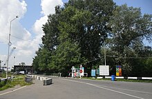
Checkpoint at the border The current border was established after World War II when Zakarpattia Oblast was admitted into Ukraine , which at the time was part of the Soviet Union as the Ukrainian Soviet Socialist Republic . The border stretches for 136.7 km (84.9 mi) along the Tisza river valley.
After the admission of Hungary to the European Union , the border security became the responsibility of the union, as well.
See also: Roads in Hungary and Roads in Ukraine
Road Rail See also
References
Erőss, Ágnes; Kovály, Katalin; Tátrai, Partrik (2016). Effects of the Ukrainian Crisis in Transcarpathia: The Hungarian Perspective hdl :10419/180979 .
ICPDR (2008). Analysis of the Tisza River Basin 2007 (PDF) (Report). ICPDR – International Commission for the Protection of the Danube River.
External links
Categories :
Text is available under the Creative Commons Attribution-ShareAlike License. Additional terms may apply.
**DISCLAIMER** We are not affiliated with Wikipedia, and Cloudflare.
The information presented on this site is for general informational purposes only and does not constitute medical advice.
You should always have a personal consultation with a healthcare professional before making changes to your diet, medication, or exercise routine.
AI helps with the correspondence in our chat.
We participate in an affiliate program. If you buy something through a link, we may earn a commission 💕
↑
