| Divljana | |
|---|---|
| Village | |
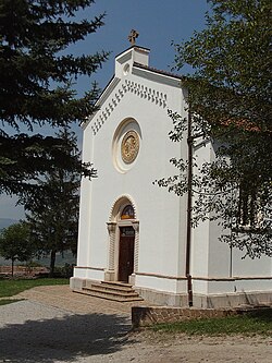
 Divljana Monastery Divljana Monastery | |
 | |
| Coordinates: 43°10′38″N 22°18′16″E / 43.17722°N 22.30444°E / 43.17722; 22.30444 | |
| Country | |
| District | Pirot |
| Municipality | Bela Palanka |
| Population | |
| • Total | 141 |
| Time zone | UTC+1 (CET) |
| • Summer (DST) | UTC+2 (CEST) |
Divljana (Serbian: Дивљана) is a village in the municipality of Bela Palanka, Serbia. According to the 2002 census, the village has a population of 141 people. Divljana Monastery is one of the landmarks in Divljana.
Zapis oak

There is a large old oak tree in Divljana that is a zapis ("inscription"), a village tree considered sacred. In a custom originating in pre-Christian Slavic mythology, a large tree, usually an oak, would have a cross carved into its bark, and would serve as a temple. Oak trees were sanctified in the settlements which had no church of their own. Experts from the Niš Institute for the natural protection estimated that it sprouted in c. 1400.
The trunk is completely open and hollow on one side. Inside, eight adults can fit, or a table and chairs. The tree, a durmast oak, is under state protection as a natural monument. Circumference of the Divljana oak trunk (as of 2017) is 6.35 m (20.8 ft), diameter is 2.02 m (6 ft 8 in), while the diameter of the crown is 23.13 m (75.9 ft). The tree is 13.43 m (44.1 ft) tall.
References
- Popis stanovništva, domaćinstava i Stanova 2002. Knjiga 1: Nacionalna ili etnička pripadnost po naseljima. Republika Srbija, Republički zavod za statistiku Beograd 2003. ISBN 86-84433-00-9
- ^ Zoran Stojanović (27 November 2017), "Ima li leka za hrast u selu Divljana" [Is there a remedy for the oak in the village of Divljana], Politika (in Serbian), p. 23
External links
43°10′38″N 22°18′16″E / 43.17722°N 22.30444°E / 43.17722; 22.30444
This Pirot District, Serbia location article is a stub. You can help Misplaced Pages by expanding it. |