| Zillisheim Zìllesa (in Haut Rhin Alsatian) | |
|---|---|
| Commune | |
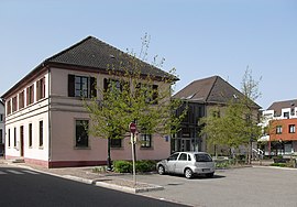
 The town hall in Zillisheim The town hall in Zillisheim | |
 Flag Flag Coat of arms Coat of arms | |
| Location of Zillisheim | |
  | |
| Coordinates: 47°41′46″N 7°17′47″E / 47.6961°N 7.2964°E / 47.6961; 7.2964 | |
| Country | France |
| Region | Grand Est |
| Department | Haut-Rhin |
| Arrondissement | Mulhouse |
| Canton | Brunstatt-Didenheim |
| Intercommunality | Mulhouse Alsace Agglomération |
| Government | |
| • Mayor (2020–2026) | Michel Laugel |
| Area | 8.22 km (3.17 sq mi) |
| Population | 2,514 |
| • Density | 310/km (790/sq mi) |
| Demonym(s) | Zillisheimois, Zillisheimoises |
| Time zone | UTC+01:00 (CET) |
| • Summer (DST) | UTC+02:00 (CEST) |
| INSEE/Postal code | 68384 /68720 |
| Elevation | 247–404 m (810–1,325 ft) (avg. 252 m or 827 ft) |
| French Land Register data, which excludes lakes, ponds, glaciers > 1 km (0.386 sq mi or 247 acres) and river estuaries. | |
Zillisheim (Alsatian: Zellesa or Zìllesa) is a commune in the Haut-Rhin department of Alsace in north-eastern France. It forms part of the Mulhouse Alsace Agglomération, the inter-communal local government body for the Mulhouse conurbation.
Population
|
| ||||||||||||||||||||||||||||||||||||||||||||||||||||||||||||||||||||||||||||||||||||||||||||||||||||||||||||||||||
| |||||||||||||||||||||||||||||||||||||||||||||||||||||||||||||||||||||||||||||||||||||||||||||||||||||||||||||||||||
| Source: EHESS (1793-1999) and INSEE | |||||||||||||||||||||||||||||||||||||||||||||||||||||||||||||||||||||||||||||||||||||||||||||||||||||||||||||||||||
See also
References
- "Répertoire national des élus: les maires" (in French). data.gouv.fr, Plateforme ouverte des données publiques françaises. 13 September 2022.
- "Populations légales 2021" (in French). The National Institute of Statistics and Economic Studies. 28 December 2023.
- André Nisslé. "Nos villes et villages du Haut-rhin. Unsra Schtätt un Därfla vum Owerlànd". www.elsassisch.eu (in French). Retrieved 9 June 2019..
- "Mulhouse Alsace Agglomération". Mulhouse Alsace Agglomération. Retrieved 2011-04-07.
- Des villages de Cassini aux communes d'aujourd'hui: Commune data sheet Zillisheim, EHESS (in French).
- Population en historique depuis 1968, INSEE
External links
- Official website of the Commune of Zillisheim
This Haut-Rhin geographical article is a stub. You can help Misplaced Pages by expanding it. |