| Yahorlyk Kut | |
|---|---|
| Peninsula | |
 | |
| Coordinates: 46°17′59″N 31°49′47″E / 46.29972°N 31.82972°E / 46.29972; 31.82972 | |
| Location | Skadovsk district, Kherson Oblast, Ukraine |
| Part of | |
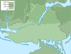
Yahorlyk Kut (Ukrainian: Ягорлицький Кут) is a peninsula in Southern Ukraine that separates Yahorlyk Bay from the Gulf of Tendra. Administratively the peninsula is part of Skadovsk Raion.
From 1959 to 1994 it was used by the Soviet Air Force as a bombing range.
References
External links
- Echoes of the Ancient Borysthenes. "Naddnipryanska Pravda plyus" at the Kherson Arts portal. 1 November 2013
This article about a location in Kherson Oblast is a stub. You can help Misplaced Pages by expanding it. |