| Tai Mun Shan | |
|---|---|
| 大蚊山 | |
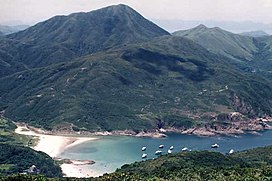
 Tai Mun Shan rising behind the bay of Sai Wan Tai Mun Shan rising behind the bay of Sai Wan | |
| Highest point | |
| Elevation | 370 m (1,210 ft) |
| Coordinates | 22°24′56.21″N 114°21′53.12″E / 22.4156139°N 114.3647556°E / 22.4156139; 114.3647556 |
| Geography | |
 | |
| Location | Eastern New Territories, |
Tai Mun Shan (Chinese: 大蚊山; Cantonese Yale: daaih mān shāan) lies to the west of Tai Long Wan near Chek King on the Sai Kung Peninsula in Hong Kong. The hill comprises a rounded peak, which rises to a height 370 metres (1,210 feet).
The name translates as the Big Hill of the Mosquitoes.
See also
This New Territories location article is a stub. You can help Misplaced Pages by expanding it. |
This article related to a mountain or hill in Hong Kong is a stub. You can help Misplaced Pages by expanding it. |