| This article does not cite any sources. Please help improve this article by adding citations to reliable sources. Unsourced material may be challenged and removed. Find sources: "Sapulut" – news · newspapers · books · scholar · JSTOR (July 2022) (Learn how and when to remove this message) |
Place in Sabah, Malaysia
| Sapulut | |
|---|---|
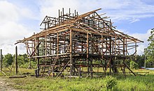
 New houses in Sapulut New houses in Sapulut | |
 | |
| Coordinates: 4°42′0″N 116°29′0″E / 4.70000°N 116.48333°E / 4.70000; 116.48333 | |
| Country | |
| State | |
Sapulut is a town along Sapulut River in the Interior Division of Sabah, Malaysia. Mount Antulai (1713 metres) is located about 5 kilometres from the town. Nearby the town is the Batu Punggul limestone massif and cave, a popular spot for eco-tourists. The proposed new highway connecting Sapulut and Kalabakan in the Tawau Division is expected to be completed in mid-2007, and when completed will make road travel between Kota Kinabalu and Tawau easier and faster.

| State of Sabah | |||||||||||
|---|---|---|---|---|---|---|---|---|---|---|---|
| Capital: Kota Kinabalu | |||||||||||
| Topics | |||||||||||
| Society | |||||||||||
| Administrative divisions |
| ||||||||||
This Sabah location article is a stub. You can help Misplaced Pages by expanding it. |