| This article does not cite any sources. Please help improve this article by adding citations to reliable sources. Unsourced material may be challenged and removed. Find sources: "Paika" – news · newspapers · books · scholar · JSTOR (June 2019) (Learn how and when to remove this message) |
Town in Kerala, India
| Paika | |
|---|---|
| Town | |
 | |
| Coordinates: 9°39′0″N 76°43′0″E / 9.65000°N 76.71667°E / 9.65000; 76.71667 | |
| Country | India |
| State | Kerala |
| District | Kottayam |
| Population | |
| • Total | 8,978 |
| Languages | |
| • Official | Malayalam, English |
| Time zone | UTC+5:30 (IST) |
| Vehicle registration | KL-35 |
| Nearest city | Kottayam, Palai, Kanjirappally |
| Lok Sabha constituency | Kottayam |
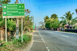
Paika is a small town 8 kilometres (5.0 mi) from Palai on the Pala-Ponkunnam road of Muvattupuzha - Punalur SH:08, in Kottayam district, Kerala, India. It is part of Meenachil Taluka, known as one of the most fertile agricultural regions of Travancore. This region is part of the mid-lands (adjacent to the high ranges) of south-eastern Kerala. The main income is from agriculture, mostly rubber plantations.
References
| Cities and towns in Kottayam district | |
|---|---|
| Kottayam | |
This article related to a location in Kottayam district, Kerala, India is a stub. You can help Misplaced Pages by expanding it. |