| Lulonga River | |
|---|---|
 The Lulonga River at the port of Basankusu The Lulonga River at the port of Basankusu | |
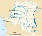
 The rivers of the central Democratic Republic of Congo, with the Lulonga and its tributaries (top left) The rivers of the central Democratic Republic of Congo, with the Lulonga and its tributaries (top left) | |
| Location | |
| Country | Democratic Republic of the Congo |
| Physical characteristics | |
| Mouth | |
| • location | Congo River |
| Length | 200 km (120 mi) |
| Basin size | 76,950 km (29,710 sq mi) |
| Discharge | |
| • location | Confluence of Congo (near mouth) |
| • average | 2,040 m/s (72,000 cu ft/s) |
| Basin features | |
| Tributaries | |
| • left | Maringa |
| • right | Lopori |
The Lulonga (Swahili: Mto Lulonga, French: Rivière Lulonga, Dutch: Lulonga Rivier) is a river in the Equateur province of Democratic Republic of the Congo. It is about 200 km long from its beginning at the town of Basankusu. The Lopori and the Maringa join to form the Lulonga there. The Lulonga River flows into the Congo River at the village of Lulonga.
References
- Thibault, Lambert; Steven, Bouillon; François, Darchambeau; Philippe, Massicotte; Alberto, V. Borges. "Shift in the chemical composition of dissolved organic matter in the Congo River network" (PDF). Archived (PDF) from the original on 2023-05-29. Retrieved 2023-05-29.
- Jef Dupain; Janet Nackoney; Jean-Paul Kibambe; Didier Bokelo & David Williams. "Maringa-Lopori-Wamba Landscape" (PDF). L'Observatoire des Forêts d'Afrique Centrale. Archived from the original (PDF) on 2016-03-03. Retrieved 2011-10-14.
| Rivers of the Democratic Republic of the Congo | ||
|---|---|---|
| Congo left bank (south) |  | |
| Kasai basin | ||
| Congo right bank (north) | ||
| Lualaba and tributaries | ||
| Other | ||
0°38′40″N 18°22′58″E / 0.644489°N 18.3827877°E / 0.644489; 18.3827877
This article related to a river in the Democratic Republic of the Congo is a stub. You can help Misplaced Pages by expanding it. |