| This article needs additional citations for verification. Please help improve this article by adding citations to reliable sources. Unsourced material may be challenged and removed. Find sources: "Haroldswick" – news · newspapers · books · scholar · JSTOR (July 2007) (Learn how and when to remove this message) |
| Haroldswick | |
|---|---|
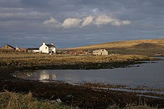
 At Haroldswick beach, the white building is Bordanoost and the grey buildings just right of centre are the houses of Beach Road. At Haroldswick beach, the white building is Bordanoost and the grey buildings just right of centre are the houses of Beach Road. | |
 | |
| OS grid reference | HP634121 |
| Civil parish | |
| Council area | |
| Lieutenancy area | |
| Country | Scotland |
| Sovereign state | United Kingdom |
| Post town | SHETLAND |
| Postcode district | ZE2 |
| Dialling code | 01595 |
| Police | Scotland |
| Fire | Scottish |
| Ambulance | Scottish |
| UK Parliament | |
| Scottish Parliament | |
| 60°47′17″N 0°50′02″W / 60.788°N 0.834°W / 60.788; -0.834 | |
Haroldswick or Harold's Wick (Old Norse: Haraldsvík, 'Harald's bay'), is on Unst, Shetland Islands, Scotland, and is one of the most northerly settlements in the British Isles.
History
The wick takes its name from the Viking King Harald I Fairhair, and is reputed to be the first landing point for the Vikings in the Shetland Islands. A Viking grave, attributed to Harold, has been found on the nearby Setter's Hill, overlooking the landing point.
Geography
It sits at the end of a small bay in a crescent moon shape with a hill on either side, with steep cliffs and rough waters with good mackerel fishing grounds underneath. The beach is rocky until it comes to an old ruin of a pier, then it has huge boulders blocking traveller's way. Lining the beach are little cottages with their only barrier against the winds from the sea being a small wall on the other side of the road. A small maritime museum dedicated to the traditional small boats of Shetland, the Unst Boat Haven, is located at the head of the bay and is open to visitors from May to September. The beach is frequently populated with grey seals and grey herons. The depth is shallow for about 6 metres, then deepens considerably.
Location


The bay is located some 615 km (382 mi) north of the closest mainland UK city, Inverness, in Scotland's Highland region and 1,310 km (810 mi) from London. Even Lerwick, the Shetland's capital and only town, is some 96 km (60 mi) to the south. However, Haroldswick's claim to be the northernmost settlement in the UK is surpassed by the tiny hamlet of Norwick-Skaw, situated 8 km (5.0 mi) to the north.
The Methodist Church at Haroldswick is the northernmost church in Britain.
For many years, Haroldswick Post Office was the most northerly in the UK and visitors could get a special postmark. Since the office's closure in 1999, this record is now held by the post office in Baltasound, also on Unst.
References
External links
- Undiscovered Scotland - Haroldswick
- Unst Heritage Centre, Haroldswick Archived 18 November 2022 at the Wayback Machine
| North Isles, Shetland Islands | ||
|---|---|---|
| Inhabited islands | ||
| Other islands | ||
| Towns and villages | ||
| Points of interest | ||
| Shetland | ||
|---|---|---|
| Inhabited islands | ||
| Other islands | ||
| Towns and villages | ||
| Mainland Parishes | ||
| Insular Parishes | ||
| Maritime features | ||
Extreme points
| ||
| Topics | ||
| Marine Protected Areas in Scotland | |
|---|---|
| Historic Marine Protected Areas | |
| Nature Conservation MPAs |
|
| Demonstration and Research MPA | |
This Shetland location article is a stub. You can help Misplaced Pages by expanding it. |